

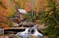
West Virginia: Mountainous West Virginia covers over 24,000 square miles. The highest point in the state is Spruce Knob in Pendleton County with an elevation of 4,861 feet. The lowest point in the state is the town of Harpers Ferry in Jefferson County with an elevation of 247 feet above sea level. Nearly 80% of the state is covered by forests.


Geography
West Virginia covers over 24,000 square miles. The highest point in the state is Spruce Knob in Pendleton County, with an elevation of 4,861 feet and the lowest point is Harpers Ferry in Jefferson County at an elevation of 247 feet. Nearly 80% of the state is covered by forests. West Virginia has 1,000,000 acres of recreation areas including 2 national parks, 36 state parks, nine state forests, 47 wildlife management areas and two national forests.
Population
Approximately 1.8 million people live in West Virginia. The population is expected to rise only slightly by the year 2025.
Income
In 2015 the median household income was $41,751.
Real Estate
The 2011-2015 state homeownership rate was 72.5%.
Industry
The state is a global hub for chemicals, a national hub for biotech industries and a leader in energy, while having a diverse economy in aerospace, automotive, healthcare and education, metals and steels, media and telecommunications, manufacturing, hospitality, biometrics, forestry, and tourism.
Sites/Landmarks
Whitewater rafting is a popular sport in West Virginia with over 200 miles of river designated for commercial rafting. Skiing is a popular winter sport. The state capital of Charleston includes a cultural center, several museums and a planetarium.
Quick Links
Mortgage Calculator
These figures are ESTIMATES only, NOT A GUARANTEE, and are SUBJECT TO CHANGE. If you misenter your information, the payment information will remain empty.
This data last updated on 2024-04-25 00:06:56.
Some properties which appear for sale on this web site may subsequently have sold or may no longer be available. Listing information on the web site is from the IDX program of Bright MLS.
©Copyright 1998- The GoHome Networks, Inc. All Rights Reserved.
Terms of Use and Privacy Policy
All information provided is deemed reliable but is not guaranteed and should be independently verified. The advertisements herein are merely indications to bid and are not offers to sell which may be accepted. All properties are subject to prior sale or withdrawal. All rights are reserved by copyright.
| Equal Housing Opportunity |